
Detecting change, supporting action: the Automated land use mapping of urban dynamics prototype
24 Jul 2025
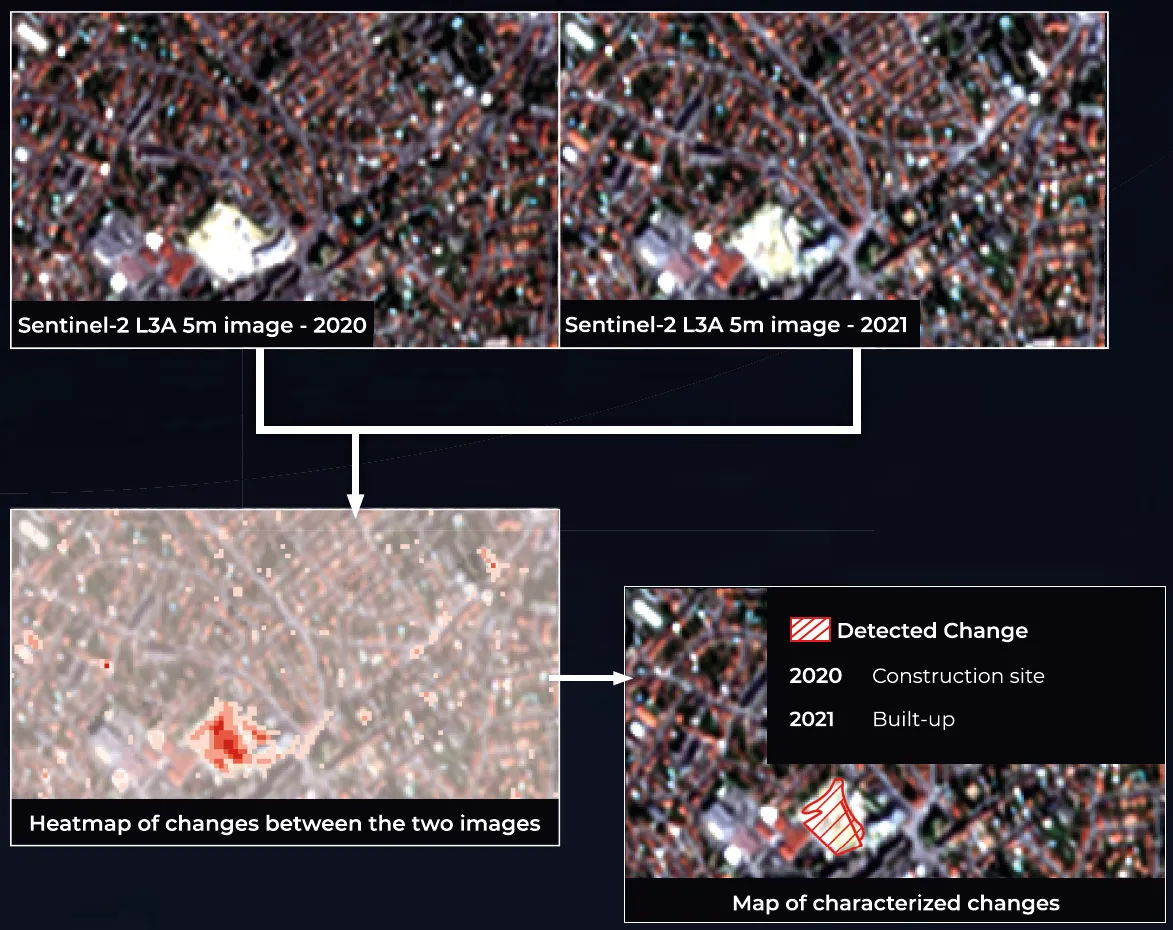
The C9 prototype marks a significant shift from traditional static land monitoring approaches by enabling annual detection and characterization of urban change. This high-frequency update capacity empowers decision-makers to respond more quickly and accurately to urban development trends, risks, or violations of policy.
At the heart of this innovation lies a robust processing pipeline capable of identifying and mapping urban changes at one-year intervals, a novelty for some Copernicus Land Monitoring Service (CLMS) products such as the Urban Atlas, which has traditionally relied on multi-year update cycles.
How it works
The strength of the C9 prototype lies in its smart integration of established methods and cutting-edge technology:
- Automated 1-year interval change maps: A dedicated processing chain produces consistent, high-frequency outputs, which can be part of policy frameworks or operational workflows.
- Principal Component Analysis (PCA): At the core of the change detection process is PCA, which enhances robustness by distilling the most relevant spectral changes from satellite imagery.
- Machine Learning classification: The system classifies land cover types through Random Forest algorithm.
- Super-resolution and in-situ integration: Drawing from EvoLand’s method development innovations, the prototype enhances the spatial detail of detected changes, offering clearer insights on fine-scale urban dynamics.
The C9 workflow
Policy-Relevant Use Cases
Designed to go beyond observation, the C9 prototype is built to serve real-world policy needs and urban governance challenges:
- No Net Land Take (NNLT): Tracks whether new developments encroach on natural or previously urbanized land, supporting efforts to meet the EU’s 2050 zero land take target.
- Informal dumping detection: By identifying unexpected land use changes, the prototype can flag potential illegal waste dumping.
- Project monitoring: Urban development projects, whether private or public, can be monitored for alignment with planning approvals, offering authorities and investors a way to validate progress over time.
Supporting smarter cities
By offering automated, detailed, and timely insights, the EvoLand C9 prototype supports local authorities, urban planners, and policymakers as they work to manage the complexity of Europe’s urban fabric. It allows them to anticipate problems, enforce regulations, and plan with confidence, all while aligning with the broader goals of sustainable urban development and climate resilience.
Newsletter
Stay current! Subscribe to our EvoLand newsletter!