Super-Resolution Satellites: how AI reveals the details of Sentinel-2
23 Oct 2025
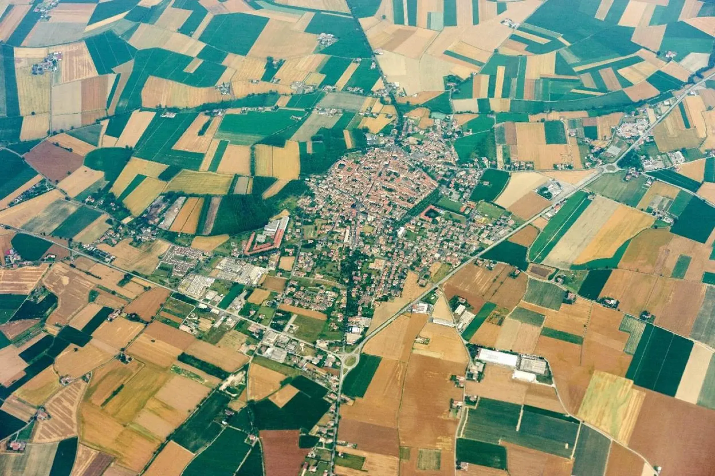
Sentinel-2 has been a workhorse for Europe’s land monitoring, offering 10–20 meter resolution imagery with global coverage. Yet for many real-world challenges — from identifying subtle differences within a single agricultural field to detecting small-scale urban expansion — this resolution is not quite enough. EvoLand confronted this limitation not by waiting for the next generation of satellites, but by teaching today’s imagery to reveal more detail through artificial intelligence.
The method at the heart of this innovation is Single Image Super-Resolution (SISR), a deep learning approach that reconstructs fine spatial features beyond the original resolution of the sensor. Unlike traditional upscaling, which simply enlarges pixels and produces blurred results, SISR learns from vast quantities of training data to predict what finer-scale details should look like. EvoLand’s model enhances Sentinel-2 imagery down to 5 metres, effectively doubling the level of detail without altering the underlying radiometry (D2.17, Section 3.1, pp. 133–165).
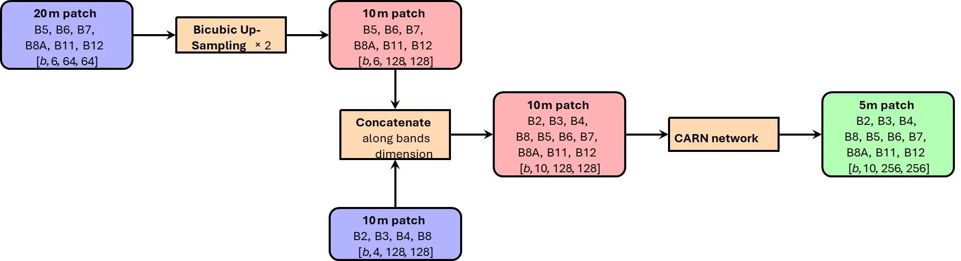
To make this feasible at scale, the team turned to the CARN (Cascading Residual Network) architecture, which strikes a careful balance between accuracy and efficiency. The model is lightweight enough to process Europe-wide archives of Sentinel-2 data, yet sophisticated enough to reconstruct sharp features in forests, croplands, and cities. Rigorous benchmarking confirmed that the super-resolved images maintain radiometric fidelity, meaning they can be used directly in downstream applications such as classification or biomass estimation without additional recalibration.v
Workflow of the joint 10m-20m SISR model, using the CARN backbone. Tensor shapes are indicated, where b stands for the batch dimension
Beyond SISR: TAMRF for Fusion and Gapless Monitoring
Building on SISR, EvoLand also introduced a more ambitious framework: Time Attention Multi-Resolution Fusion of Satellite Image Time Series (TAMRF). While SISR sharpens individual images, TAMRF is designed to merge information from multiple satellites and across time, addressing a wider set of challenges such as cloud gaps, missing acquisitions, and multi-sensor integration.
TAMRF combines the strengths of convolutional neural networks for spatial detail with transformer architectures for temporal reasoning
In practice, it encodes Sentinel-2 and Landsat series into a shared latent representation that retains both sensor identity and acquisition timing. The decoder then reconstructs high-resolution time series on demand, filling in cloudy periods, predicting unseen dates, or super-resolving low-resolution bands.
Overview of the proposed method.S_LR (in green) and (in blue) are fed into the TAMRF encoder, which outputs latent representation S_latent (in red). The latent representation is fed into the TAMRF decoder, along with T_query, which outputs S_LR^⋆ (in green) and S_HR^⋆ (in red)
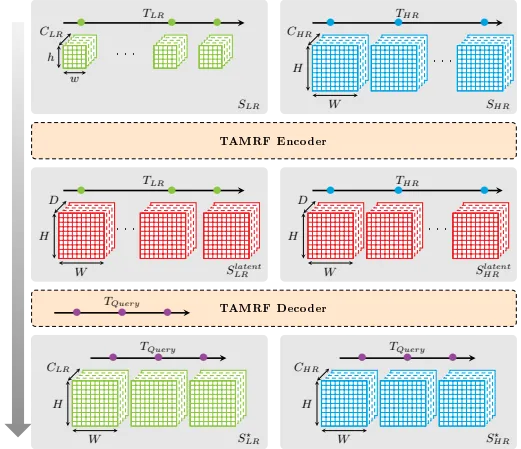
This flexibility allows the model to support multiple tasks simultaneously — sensor translation, temporal interpolation, super-resolution, and even forecasting.
Illustration of the TAMRFmodel capabilities over Area Of Interest 31TFJ for year 2022 (from the test set). Landsat SITS has 51 dates, of which 26 dates are removed from the model input and kept for validation. Sentinel-2 has 81 dates, of which 41 are removed from the model input and kept for validation. In this figure, images that are part of the model inputs are highlighted in green, model predictions are highlighted in red, and reference images are highlighted in blue. From top to bottom: rows 1 and 2 shows prediction for an observed Landsat date, row 3 shows prediction for a cloudy Landsat date, row 4 shows prediction for an observed Sentinel-2 date, row 5 shows prediction for a cloudy Sentinel-2 date, and row 6 shows predictions for an unobserved date.
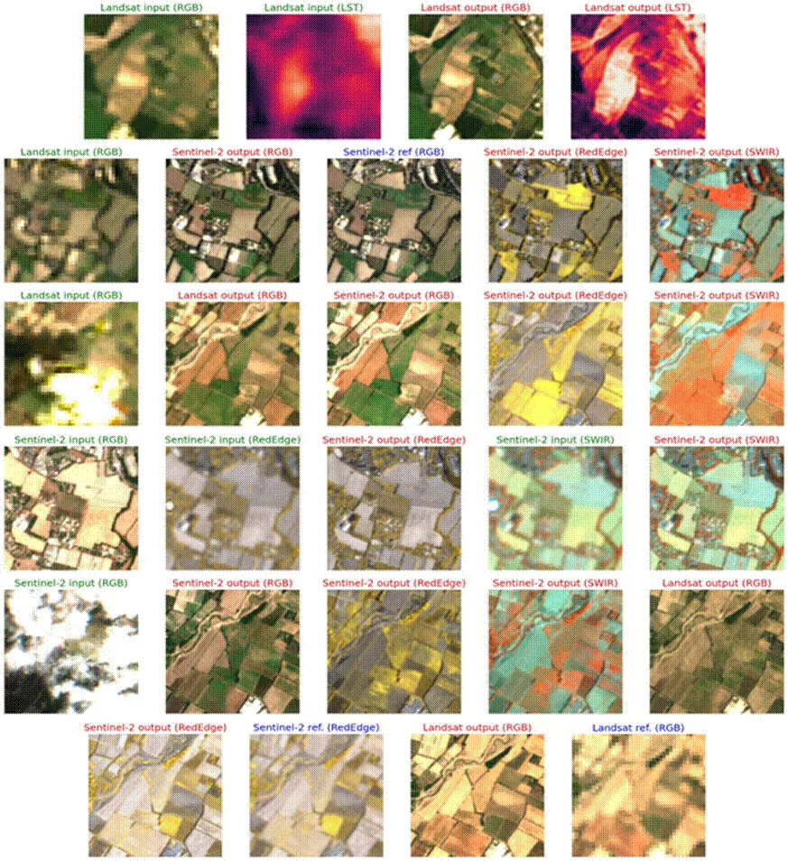
Unlike earlier methods that require paired acquisitions or retraining for each target date, TAMRF needs to be trained only once and consistently delivers gapless outputs that align with reference Sentinel-2 data, whatever the length and temporal density of the input time-series.
Benchmarking shows that TAMRF consistently outperforms existing methods such as Deep-Harmo, with 2–3 times lower RMSE and sharper preservation of fine details.
Crucially, it achieves this without relying on Landsat’s panchromatic band, instead leveraging the full temporal and spectral richness of the combined time series.
Why This Matters
Together, SISR and TAMRF highlight how much more can be extracted from today’s Earth observation archives. Super-resolution delivers sharper imagery at field scale without waiting for new satellites, while TAMRF fuses multi-sensor time series into seamless, high-resolution products. These innovations open the door to more detailed agricultural monitoring, more reliable detection of forest disturbances, and better tracking of urban growth — ensuring that Copernicus Land Monitoring Services can provide richer insights at no additional acquisition cost.
Resources
Source code: https://github.com/Evoland-Land-Monitoring-Evolution/tamrfsits
Revision 1 of paper: https://hal.science/hal-05101526v2
Results from paper: https://doi.org/10.5281/zenodo.17474541
Datasets: https://doi.org/10.5281/zenodo.15471890 and https://doi.org/10.6096/1029
Newsletter
Stay current! Subscribe to our EvoLand newsletter!